New Oceanographic Survey Drone Can Take Off, Land, and Sail on the Water

 This article published in collaboration with JUIDA, the Japan UAS Industrial Development Association.
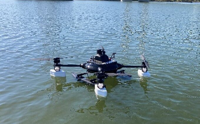
Penta Ocean Construction (President, Takuzo Shimizu) and Prodrone Co., Ltd. (President, Shunsuke Toya) have jointly developed the “Penta-Ocean Vanguard-DroneAqua” (POV-DA), an innovative oceanographic survey drone capable of taking off, landing, and sailing on the sea.


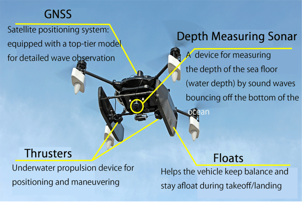
The POV-DA is designed for seamless water operations, equipped with a high-precision GNSS satellite system, thrusters, and a depth-measuring sonar. According to a Penta Ocean press release, the drone can transmit and display real-time data on its current location (X, Y, Z coordinates) and water depth to operators on land through a remote control console. The drone can navigate to specific monitoring points using its thrusters, maintaining position despite waves and swells. These capabilities enable efficient and automated bathymetric surveys and wave observations.


Bathymetric Surveys
In construction projects involving breakwaters, quay walls, and similar structures, depth sounding has traditionally been performed using dedicated boats or lead sounding methods. With the introduction of POV-DA, the time required for depth surveys is significantly reduced. Real-time data transmission allows operators to monitor underwater construction progress and assess the need for additional soil dumping. The team confirmed that the POV-DA’s depth surveying accuracy is within +/-10cm of traditional methods, making it suitable for practical construction management.
Wave Observation
Marine construction management and safety often rely on weather and marine forecast data, as well as wave height measurements near the project site. Visual checks from the coastline are also performed to assess project feasibility. The POV-DA provides real-time wave height and period data derived from GNSS readings, allowing construction managers to assess site conditions more quickly and accurately. The drone’s measurements have been shown to vary by +/-10% or less compared to conventional wave meters, demonstrating its reliability for construction applications.
In addition to improving construction management efficiency and feasibility assessments, the POV-DA can take aerial shots for emergency support during disasters, providing real-time updates on land and underwater damages.
Future enhancements to the POV-DA may include additional equipment such as multi-parameter water quality meters and water sampling devices, broadening its applications to coastal environment preservation and comprehensive marine observations in construction projects.
Read more:
Miriam McNabb is the Editor-in-Chief of DRONELIFE and CEO of JobForDrones, a professional drone services marketplace, and a fascinated observer of the emerging drone industry and the regulatory environment for drones. Miriam has penned over 3,000 articles focused on the commercial drone space and is an international speaker and recognized figure in the industry. Miriam has a degree from the University of Chicago and over 20 years of experience in high tech sales and marketing for new technologies.
For drone industry consulting or writing, Email Miriam.
TWITTER:@spaldingbarker
Subscribe to DroneLife here.


